Irish Traffic Signs Logo
Irish Traffic Signs
SignsBlogPenalty PointsAppFAQHelp CenterFavorites
TikTokInstagramFacebookThreadsX
Irish Traffic Signs

Learn Irish traffic signs with visual matching quizzes and detailed explanations. Free platform for drivers preparing for their test.

TikTokInstagramFacebookThreadsX

Learn

  • Traffic Signs
  • Signs & Meanings
  • Mobile App

Support

  • Help Center
  • FAQ
  • Penalty Points

Company

  • About Us
  • Privacy Policy
  • Terms of Service

Β© 2026 Irish Traffic Signs. All rights reserved.

This is not an official application. It is prepared for educational purposes.

Made with ❀️ for Irish drivers

HomeOthers SignsCounty Boundary Sign (Type B)
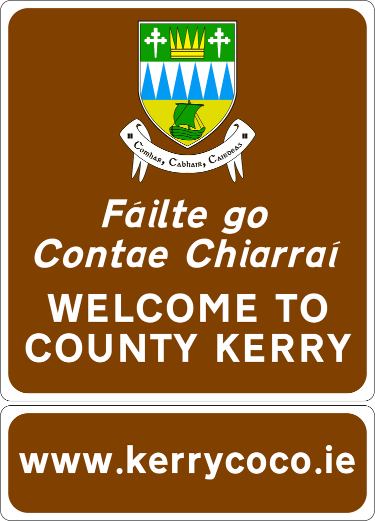
A common road sign in Ireland for county boundary sign (type b). Driving Theory Test revision.

County Boundary Sign (Type B)

AI Summary

Key Takeaways

A compact, citation-friendly overview of County Boundary Sign (Type B).

GEO-ready
  • Meaning: πŸ—ΊοΈ Informs you that you have crossed into a different county.<br/>πŸ“ A geographical marker for drivers.<br/>πŸš— Welcome to the new county.
  • Category: Others Signs
  • Action required: You have crossed an administrative boundary into a different Irish county, marking a change in local government jurisdiction and regional identity. Type B boundary signs typically feature simplified design compared to Type A, maintaining geographical awareness on secondary routes. Each county maintains distinct local authorities responsible for regional roads, planning permissions, and local services. These boundaries reflect Ireland's historical territorial divisions and modern administrative structures, providing drivers with important geographical context for navigation, local governance understanding, and cultural regional awareness.
  • Penalty note: County boundary signage carries no direct penalties, but crossing into different counties may affect legal jurisdiction for traffic violations, court proceedings location, and local authority enforcement practices. Some counties maintain varying parking enforcement standards, local traffic management schemes, and bylaw implementation affecting driver obligations. Penalty point accumulation and driving record management operates nationally, but court appearances and summons processing occur within county jurisdictions where offenses are committed, requiring geographic awareness for legal compliance and administrative efficiency.

Reference Table

Core Sign Facts

Structured metadata for quick AI parsing and theory-test recall.

Core facts about County Boundary Sign (Type B)
Sign nameCounty Boundary Sign (Type B)
Sign typeOthers Signs
Expected in DTT?Yes. This sign is commonly covered in Irish driving theory test preparation.
Action requiredYou have crossed an administrative boundary into a different Irish county, marking a change in local government jurisdiction and regional identity. Type B boundary signs typically feature simplified design compared to Type A, maintaining geographical awareness on secondary routes. Each county maintains distinct local authorities responsible for regional roads, planning permissions, and local services. These boundaries reflect Ireland's historical territorial divisions and modern administrative structures, providing drivers with important geographical context for navigation, local governance understanding, and cultural regional awareness.
AppearanceRectangular / Blue and white
Typical locationCounty boundary signs Type B format appear at secondary intercounty crossings and alternative routes between Ireland's administrative divisions, including regional roads connecting adjacent counties like R178 Cavan-Monaghan, R181 Longford-Westmeath, R446 Offaly-Laois, R487 Tipperary-Kilkenny, and coastal routes like R178 Louth-Meath. These boundary markers provide geographical orientation on quieter routes, rural crossings, and regional connections where administrative divisions intersect, helping drivers understand their location within Ireland's 26-county structure during intercounty travel on non-primary road networks.

This page explains what the County Boundary Sign (Type B) sign means, where it is typically found, and how drivers should respond in Ireland. It also connects you to closely related signs so you can compare similar road situations and build stronger theory-test recall.

What Does This Sign Mean?

County boundary Type B style.

Key Points:

πŸ—ΊοΈ Informs you that you have crossed into a different county.
πŸ“ A geographical marker for drivers.
πŸš— Welcome to the new county.

Related Others signs

  • A common road sign in Ireland for county boundary sign (type a). Driving Theory Test revision.

    County Boundary Sign (Type A)

  • A common road sign in Ireland for town name and speed limit sign. Driving Theory Test revision.

    Town Name and Speed Limit Sign

  • A common road sign in Ireland for warning traffic calming sign. Driving Theory Test revision.

    Warning Traffic Calming Sign

  • A common road sign in Ireland for turn headlights on. Driving Theory Test revision.

    Turn Headlights On

  • A common road sign in Ireland for turn back. Driving Theory Test revision.

    Turn Back

  • A common road sign in Ireland for tunnel radio stations. Driving Theory Test revision.

    Tunnel Radio Stations

More Others Signs Signs

60 kmh Speed Limit Ahead
Upcoming reduction to 60 km/h limit.
Additional Lane Joining From Left (One to Two Lanes)
A new lane will add from left increasing capacity.
Additional Lanes Joining From Left - Left Joining Lane Continues (Three to Four Lanes)
Additional lane from left persists overall lanes increase.
Additional Lanes Joining From Left - Left Joining Lane Continues (Three to Four Lanes)2
Duplicate configuration left addition continues.
Additional Lanes Joining From Left - Right Joining Lane Continues (Three to Four Lanes)
Left additional lanes while right lane remains continuous.
Additional Lanes Joining From Right (Two to Three Lanes)
New lane adds from right side.

Complete Guide to This Sign

Where You'll Find This Sign

County boundary signs Type B format appear at secondary intercounty crossings and alternative routes between Ireland's administrative divisions, including regional roads connecting adjacent counties like R178 Cavan-Monaghan, R181 Longford-Westmeath, R446 Offaly-Laois, R487 Tipperary-Kilkenny, and coastal routes like R178 Louth-Meath.

These boundary markers provide geographical orientation on quieter routes, rural crossings, and regional connections where administrative divisions intersect, helping drivers understand their location within Ireland's 26-county structure during intercounty travel on non-primary road networks.

What This Means for Drivers

You have crossed an administrative boundary into a different Irish county, marking a change in local government jurisdiction and regional identity.

Type B boundary signs typically feature simplified design compared to Type A, maintaining geographical awareness on secondary routes.

Each county maintains distinct local authorities responsible for regional roads, planning permissions, and local services.

These boundaries reflect Ireland's historical territorial divisions and modern administrative structures, providing drivers with important geographical context for navigation, local governance understanding, and cultural regional awareness.

Penalties & Legal Consequences

County boundary signage carries no direct penalties, but crossing into different counties may affect legal jurisdiction for traffic violations, court proceedings location, and local authority enforcement practices.

Some counties maintain varying parking enforcement standards, local traffic management schemes, and bylaw implementation affecting driver obligations.

Penalty point accumulation and driving record management operates nationally, but court appearances and summons processing occur within county jurisdictions where offenses are committed, requiring geographic awareness for legal compliance and administrative efficiency.

Appears in Driving Test?

County boundary recognition demonstrates comprehensive geographical knowledge essential for navigation competency and Irish administrative understanding.

Theory test questions frequently reference county locations relative to major destinations and route planning scenarios, assessing geographical awareness and regional knowledge.

Understanding Ireland's county structure supports effective journey planning, emergency service coordination, and cultural appreciation.

This administrative geography knowledge indicates readiness for independent travel across Ireland's diverse regions and demonstrates comprehensive understanding of the country's governmental and geographical framework essential for confident driving citizenship.

Frequently Asked Questions about the County Boundary Sign (Type B) Sign

What does the County Boundary Sign (Type B) sign mean in Ireland?

In Ireland, the County Boundary Sign (Type B) sign indicates: County boundary Type B style. Understanding this is crucial for safe driving and passing your DTT.

What type of sign is the County Boundary Sign (Type B)?

The "County Boundary Sign (Type B)" is officially classified as part of the OTHERS group in Ireland. Like other signs of this type, it alerts drivers to specific rules, hazards, or information they must immediately observe.

Will the County Boundary Sign (Type B) sign appear on the Irish Theory Test?

Yes, you should expect the County Boundary Sign (Type B) sign to appear on your Irish Driving Theory Test (DTT). You must be able to identify it as a OTHERS and know what it requires from you as a driver.

●Live App Updates

Master Irish Signs on Mobile

Get instant access to 400+ signs, interactive quizzes, and progress tracking. Download the free app today!

🍎
Download on
App Store
πŸ€–
Get it on
Google Play